
Tarsar Marsar Trek - Your Adventure Awaits
OVERVIEW DETAILS:
Region: – Kashmir
Duration: – 7 Days
Grade: – Easy to Moderate
Max Altitude: – 13,500 Ft.
Approx. Trekking Km: – 48 Kms.
BRIEF OVERVIEW:
If you wake up in the Kashmiri meadows on your way to Tarsar Marsar one day, your entire existence will melt into a distant dream. It’s as though you’ve just crossed the threshold into heaven. The Persian poet’s renowned couplet will ring true: if there is a paradise on earth, it is here, it is here, it is here! The valley of Kashmir is an experience that can rob even the most skilled writer of adjectives while instilling unending poetry in the hearts of her visitors. Aside from Kashmir’s innate classical romanticism, there are several aspects that are unique to hiking, and the Tarsar Marsar twin lakes trip puts them all together. Grasslands like velvet, strolling among gorgeous and scented floating pine trees, small thatched roofed hamlets populated by beautiful folks, the exquisite serenity of blue waterways, and camping beside the glacial lakes that give the journey its name. What’s more, in terms of actual hiking, Tarsar Marsar doesn’t charge a lot of physical difficulty, acclimation requirements, or omissions.
Special Note:
Due to persistent concerns of danger building in the valley, there has recently been significant anxiety about hikes in Kashmir. As a result, in a properly planned travel, and with some foresight, we would want to add an extra day or two to the 7-day schedule. These buffer days will be beneficial if we need to make an emergency stop, which we hope will not be necessary. This may be validated and expanded upon when you register for your journey.
Kashmir Great Lakes Trek
How to Get There

By Air:
Most major airlines, including Indian Airlines (www.indian-airlines.nic.in), Jet Airways (www.jetairways.com), and Indigo, fly to Srinagar on a daily basis. The most convenient method to go to Srinagar is via plane from New Delhi.
By Train:
The nearest railway station to Srinagar is Jammu, which is 290 kilometres away. Jammu railway station is well connected by train to all major cities in India. There are direct rail connections from Delhi, Chennai, Bangalore, and Trivandrum.
By Bus:
The National Highway 1A connects Srinagar to the rest of the country. From Jammu, J&K State Road Transport offers nice buses. The journey to Srinagar takes around ten hours.
TOUR ITINERARY
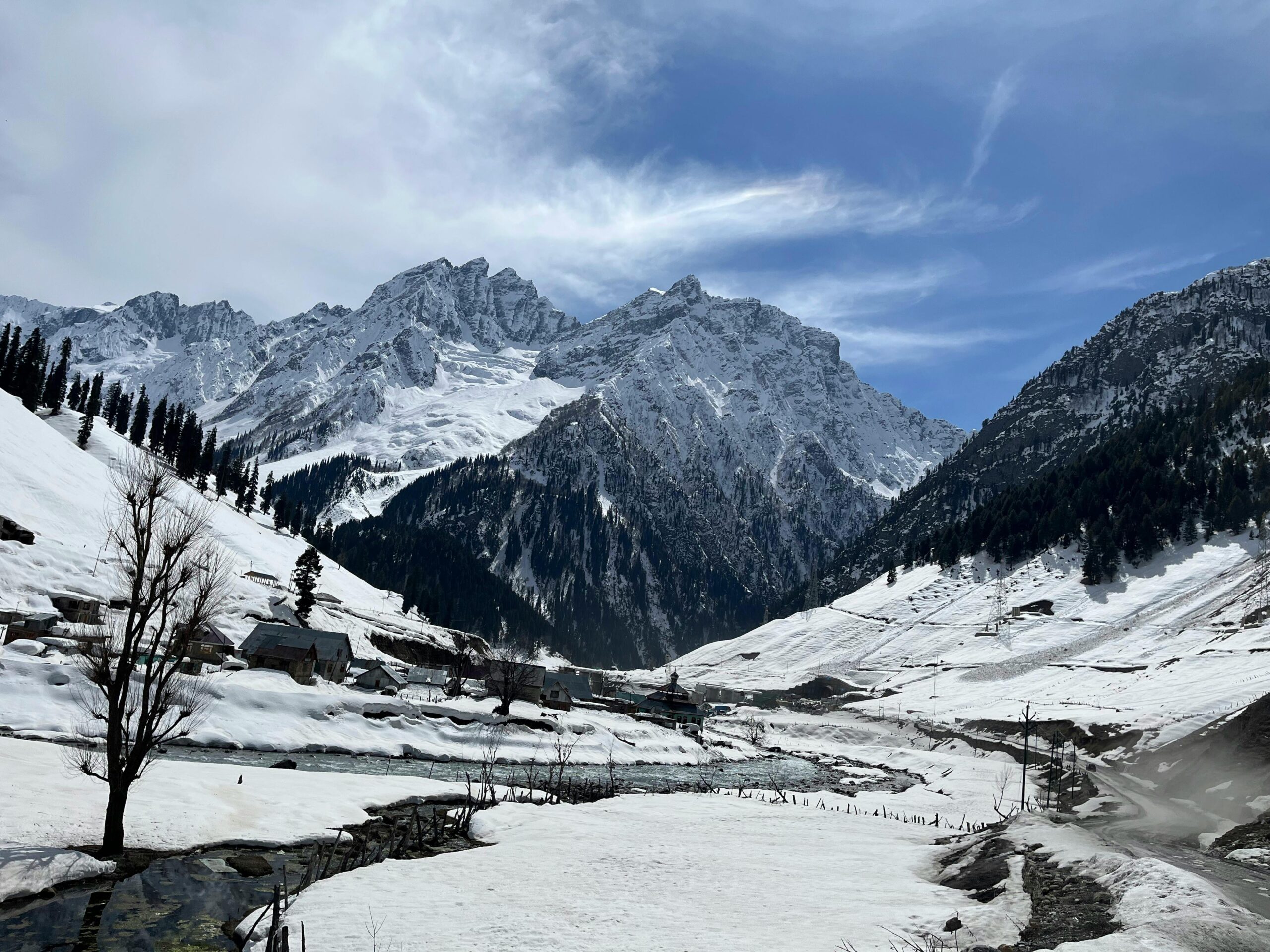
Our first day’s target is Aru, which is located 12 kilometres from Pahalgam on the banks of the Lidder and Aru rivers. Aru, a moderately established tourist stop, is considered as the primary base for two well-loved treks—the Tarsar Marsar and Kolahoi Glacier Treks, the latter of which is the source of the Lidder-Aru rivers. We will meet you in Srinagar and take you 3-4 hours to Aru via Pahalgam. Because a consistent telephonic network by all network providers cannot be guaranteed at Aru, you must end your connection with the rest of the world at Pahalgam. At Aru, you will be greeted by the lovely flowing Lidder at a river-side camping zone away from the touristic centre. There are several activities available in and around Aru, ranging from trout fishing in the Lidder, the Aru Biosphere Reserve, to horseback riding and heli skiing in the winter. You can browse and save these for a later visit because we’ll be arriving late into the evening around 6 p.m.
We’ll be following the Lidder River upstream today. The route enters a tangle of conifers after a 9-10 kilometre trek over gentle hills. Providing a panoramic view of the Aru valley to the left. We proceed under the forest shadow till we reach a clearing filled with Gujjar houses. This is the Nandekai settlement, which is home to seasonal, migratory shepherds. We won’t be travelling through the village centre, but will instead receive a valuable deep perspective of the gorgeous surroundings as we ascend higher. We’ve now reached a tumbling meadow grassland, and the fir tree thickets have totally faded. This is still a part of the Gujjar village ecology, and you will see horseback riders and cattle grazers.
As we go, the route crosses a few of little valley streams. We soon come upon a shaky log bridge that spans the second stream. This is where we will replenish our water supplies and rest, as well as maybe eat the lunch we brought from the last camp. The Lidderwat location is still an hour’s drive away.
The trail here curves into another wooded area of beautiful firs before emerging into the Lidderwat meadows, where the river flows clear watered. There are lovely tiny Gujjar villages that highlight the valley’s location. As a result of the current tourist influx, Pahalgam District Authority Huts and food establishments have been constructed for pleasant stays. Our camp would be in a calm area beside the creek. There should be enough time before dusk to wander about the quiet fir tree-shadowed Gujjar village and then relax on soft grass by the streamside in the failing light.
- Today, a 5-hour walk begins, heading right up from behind the PDA houses. Within half an hour, you will be within a pine forest, the Lidder River will be a faraway shadow, and the meadows will have ebbed away. The forests are not dense and occasionally open up into large clearings. Soon, the Lidderwat will breach to the opening of a larger expanse of merging valleys and snowy peaks rising directly from the valley rims. There will be several beautiful water streams cutting across our path where you may replenish your water bottles. You will be taken to Houmas, a small clearing occupied by another cluster of Gujjar houses on the opposite side of the now-re-emerging river that runs alongside our paths. We are led into a neighbourhood with a few residences and tea stores after crossing a wood bridge. You will always find warm welcome from these villages, and despite the weariness of travel, this brightens one’s day. We now enter a new green environment, hand in hand with the sparkling streams running by our paths. The meadows of Shekwas are as green as green can be, extending in soft folds for as far as the eye can see. Gujjar habitation and hospitality are also common in this area, with their low-roofed, leaf-thatched cottages dotting the verdant terrain here and there. Our path ascends beyond the cottages to a somewhat higher camping area. A beautiful, star-studded night descends over the fields.
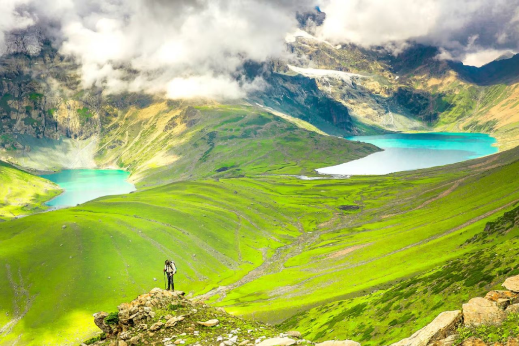
Shekwas’ lush moors are best enjoyed barefoot. Try it today when you head to Tarsar Lake. For a while, the route goes through a silky lawn of nature before taking a lunge over a humpbacked hill and, after crossing through a few hills, opens up to a little glimpse of Tarrsar’s mesmerising blue waters. It takes 5 hours to go to Tarsar from Shekwas, and another 3 hours after the crest, with the view of the Lake expanding as we descend lesser peaks. You must cross the creek, leaping from rock to boulder, until finally gliding onto lush veldt around the lake, where we would spend the night. Sink your toes into the lush grass and see how the almond-shaped water reflects the changing colours of the sky throughout the day. In the presence of such beauty and stillness, time appears to come to a halt.
Another 5 kilometre walk via the Tarsar Pass to the neighbouring Sundersar Valley begins today. We begin by exploring a connecting stretch that appears to connect the Shekwas and Sundersar Valley meadows. Trekking across the Tarsar Pass saves time but is more difficult than descending to Shekwas first and then continuing to Sundersar from there. After walking on modest undulations for many days, you may put your stamina to the test on this day’s trip. The route becomes harder on the rise to the Pass, but then flattens out to a gentler descent to Sundersar. The view of Tarsar Lake from the opposite side of the Pass is the highlight of this section. Following that, we descend to a valley bed and are met by the Bakkerwals, a nomadic shepherd clan encampment. We continue down a creek that collects at the base of snow-melting heights to form a lovely lake. The entire path is enveloped in a green drape of luminous tenderness. An otherworldly photo frame of sheep and horses bobbing around the green-scape as they graze leisurely along the shores of this nameless lake may be found. Our path leads us across a high pass exiting this grassland to the next valley, another large stretch of wide pampas sprinkled brightly with wildflowers. Later, a bouldered route across the stream leads us to the Sundersar Lake side, a flatland where we may camp at the conclusion of this extraordinary day.
Today, we’ll climb higher through Marsar Ridge. We’ll be guided to a boulder-smitten route after kilting our way around Sundarsar’s beaches. Expect treacherous snow patches in these rock crevasses, similar to the partially white covered mountains at the valley’s end that we saw on our recent hike. The snow will melt by lunchtime, making for a difficult hike. We descend to a flatland cut through by intermittent stream flows after traversing a partially grass-covered, partly snow-sheeted rock route over on the Pass. The view from the top of the ridge displays the transparent blue Marsar Lake, which is located someplace down below. It has the same almond-shaped form as Tarsar and is nearly as large.
Snow-shaded hills rise barely along one edge of the Lake, counteracting its blueness. The lake occurs to overflow on one side and pour down into a valley below in a sweeping glacial torrent. Snowmelt from the white cliffs feeds its waters on one side, while the Decigram woods begin on the other. We now make our way back to Sundersar camps and then to Homwas, practically in the same direction we came. The fall is tinged with melancholy. Homwas is reached, little weary,before nightfall.
Starting early this morning, we descend from Homwas to Aru, passing through the same lovely meadow areas and the same Lidder River, which we will now follow downstream. We will stop at Lidderwat for a rest and lunch before continuing on to Aru, a distance of 10 kilometres from Lidderwat that will take us around 4 hours to complete. Vehicles going for Srinagar would be waiting for us at Aru. We should arrive at the station about 8 p.m.
Inclusions:
- Transportation from Srinagar to the Aru Base and back
- Accommodation. (Camping) (2 persons in one tent)
- Meals while on the trail (Veg & Egg)
- Trekking gear: sleeping bag, mattress, tent (twin sharing), kitchen and dining tent, toilet tent, and utensils
- All required licences and entrance costs
- Medical first-aid supplies, stretcher, and oxygen cylinder
- Trek Leader, guide, cook, and support personnel who are mountaineering certified and professional.
- Services from Srinagar to Srinagar are available.
Exclusions:
1. Any personal costs of any sort
2. Stay in a hotel in Srinagar.
3. Food for the journey.
4. Insurance.
5. Mules or porters to transport personal belongings.
6.Anything else that isn’t expressly listed under the heading.
Srinagar Accommodation:
The last day’s stay in Srinagar is not included in the trek price. However, we can help you book a hotel or a houseboat for the same; please let us know at least 15 days before the journey begins Only email will be used for notification. info@kashmirskitours.com
SOME IMPORATANT POINTS THAT SHOULD BE NOTED:
- KST normally expects you to carry your own personal luggage; but, if you want to dump your backpack, you can give it to Mule.
- Charges for unloading a backpack:
- If you pay online 10 days in advance, the fee is INR 1800/-.
- If you notify us after reaching Aru base camp, we will give you at INR 2000/-.
- The backpack cannot be heavier than 11 kg. The cover of the backpack should be waterproof.
- Suitcases/bags will not be allowed.
- To book a Trek/adventure programme, please use our online booking form or phone us at the number.
- For tour confirmation, you must wire a deposit.
PAYING THE TREK/TOUR FEE:
- The trek/tour fee can be paid by internet transfer/check deposit/cash deposit. Payment instructions will be provided along with your confirmation email. When your transfer is complete, please send us a; confirmation email with your transfer information so that we can effectively follow up on your reservation.
BASIC GEAR:
Back Pack and Rain Cover:
- 50 – 60 ltr) with comfortable shoulder straps
- 20 – 30 ltr (If hire a mule or porter) Advisable (At least one)
- 1 Nos.
- 2 bottles of one litre each
- People who use hydration pack
- 1 hydration pack and 1 bottle of one litter
- Carry at least one thermos flask
- Energy bars, dry fruits,
- Consult your doctor
2 Full sleeves (Non-cotton)
- 1 Nos.
- 1 Nos. (Alternative: a woollen sweater)
- 1 Nos.
- 1 Pair
- 1 Pair
- 2 Synthetic (avoid shorts, fitting denims,
- Capri’s)
- 1 Nos.
BASICS GEAR:
- Back pack & rain cover:
- Day pack + rain cover:
- Walking stick:
- Head torch:
- Water bottle/Hydration pack:
- Snacks:
- Personal Medical Kit:
- Be comfy at the trek
- T-shirts
- Fleece T-shirts
- Fleece jacket
- Down feather / Hollofil jacket
- Wind & waterproof (jacket & pant)
- Thermal inners (upper and lower)
- Trek pants
- Poncho
PERSONAL UTILITIES:
- Sunscreen cream Hand sanitizer
- Moisturizer Antibacterial powder
- Toilet Paper & wipes Toothbrush
- and toothpaste
- Lip balm Quick dry towel
- Think about your head
- Sun cap 1 Nos. (One that covers
- the neck as well)
- Woollen cap 1 Nos.
- Balaclava 1 Nos.
- Neck-gaiters 1 Nos.
- Sunglasses Dark with side cover, it
- should be U/V protected.
- People who wear spectacles.
- (A)-Use Contact Lenses. (Not for Chadar Trek)
- (B) Photo Chromatic Glasses
THINK ABOUT YOUR HEAD:
- Sun Cape
- Woollen cap
- Balaclava
- Neck-gaiters
- Sunglasses
- People who wear spectacles-
- (A)- Use contact lenses. (Not for Chadar trek)
- (B)- Photo chromatic glasses.
MIND YOUR STEPS:
- Trekking shoes
- Floaters/flip-flops
- Cotton socks
- Woollen socks
- Gaiters
- KEEP THESE HANDY
- Waterproof gloves
- Fleece/woollen gloves
- If your BMI is normal, you can follow the suggested exercise routine. If your BMI is higher than normal, speak with a reputable physician before beginning a fitness regimen.
- Consult a medical professional if you have any chronic diseases.
- Take a chance and respond:
- Trekking at High Altitudes:
- Risk and Reaction
- A high altitude climb necessitates an adventurous mindset, yet starting on an adventurous expedition without first considering the dangers is sheer folly.
- That is why we have highlighted a few hazards as well as KST’s reaction to minimise or manage the risks in the best way feasible.
Altitude is a risk:
Before you begin the trip, it is critical to understand the effects of high altitude on your body. Be mindful of AMS (Acute Mountain Sickness) symptoms such as a slight headache, nausea, and overall discomfort
RESPONSE:
If you have any of these symptoms, notify the trip leader immediately and follow his advice. To meet the problem, each campground includes a stretcher, a fully stocked first aid kit, and oxygen cylinders.
Weather is a risk.:
The weather in the Himalayas is unpredictable. Even if we keep a close eye on the weather, no one can guarantee a snowstorm, rain, or sun. Please realise that your safety is of the highest concern to us, and we will not leave the campground if the weather is unfavourable.
The Trek Leaders and Guides’ choice to go or wait for better weather will be decisive.
Injury is a risk:
Minor injuries such as leg sprains, bruising, and so on are common while trekking across tough terrains. Serious injuries, such as fractures or serious cuts, are quite uncommon.
Response:
All of our Trek Leaders are trained in wilderness first aid. They have been educated to deal with emergencies and can treat minor injuries using a wellstocked first aid bag. In the event of significant injuries, the patient is transported on a stretcher to the next traffic junction and then to the nearest medical facility.
Lack of communication equipment poses a risk:
Mobile networks do not reach distant parts of the Himalayas. On a hike, one is cut off from the world of phone calls, SMS messages, and WhatsApp messages.
Response:
To communicate between the tents and the base camps, we use walkie talkies and runners